Tuesday, 6 September 2011
Carmacks Hotel & RV Park, Carmacks, YT, Canada
OK, I have been behind on the blog; but with this post I’ve caught up. Today is Tuesday, 6 September, and we’ve spent a quiet night at the Carmacks Hotel and RV Park in the Yukon. This is a busy spot for trucks headed up and down the Klondike Highway, which runs right by the RV Park, so we didn’t sleep as well last night as we might have wished. That’s OK, today is a short day driving into Whitehorse, YT. We’ve finished breakfast, and Lin has washed and put away the dishes while I catch up this journal and tell what happened last week...
Monday, 5 September 2011
Dawson City RV Park, Dawson City, YT, Canada
Monday was another travel day. We were up, not too early, had breakfast, cleaned up, hooked up the trailer, and then spent some time driving through Dawson City, just to see what had changed since we visited here about 15 years ago. There were lots of changes, the town has grown considerably, and is much more “touristy” now than it was back then. Many of the buildings which were dilapidated and falling down then have been restored, and many new ones built. I didn't take any pictures, too much tourist trappings for my interest. After our look around, we set our route down the Klondike Highway to Carmacks, YT, headed south now, bound for home over the next couple of weeks. The drive was a very beautiful one, first along the Stewart River and then along the Yukon. We stopped at several overlooks to take in the sights and I captured some pictures near Minto and at the Five Fingers Rapids overlook:
 |
| Yukon River overlook, near Minto, YT. |
 |
Overlook above Five Fingers Rapids in the Yukon River,
about 10 miles north of Carmacks, YT. |
 |
| Five Finger Rapids, Yukon River. |
 |
The stairs and path to the river, the signpost
said allow 2 hours round-trip. We passed. |
We reached the Carmacks Hotel and RV Park late in the afternoon, and set up our travel trailer beside the Yukon, a nice spot. After dinner, we played Russian Bank for a while and then called it a (very good) day...
Sunday, 4 September 2011
Sourdough Campground, Tok, AK, USA
Sunday was a mostly travel day, over some spectacular roadway, and through some interesting villages. We left Tok and headed up the Taylor Highway towards Chicken and the Top of the World Highway leading into Dawson City. The weather, as we started, was cool and partly cloudy, excellent driving weather. We made a short stop at Chicken; parts of the town seemed just as we remembered, and we had pie and ice-cream at the one old cafe there. There has been some new construction as well. The
Pedro Gold-dredge has been moved into town from its old resting place and restored. Beside it there is a new, modern RV park. We just looked around the outside of the dredge, skipped the inside tour, got some pictures, and were soon on our way again.
 |
| Beautiful downtown Chicken, AK. |
 |
| The Chicken chicken... |
 |
| The Pedro Gold Dredge, restored for you to see in Chicken, AK. |
 |
Entry gate to the dredge, with Chicken's
chicken in the background. |
 |
| Watch chicken at the gate to the dredge. |
 |
| The other guard chicken, with an admirer. |
 |
| And don't forget the guardian of the sign... |
Chicken, AK is always fun.
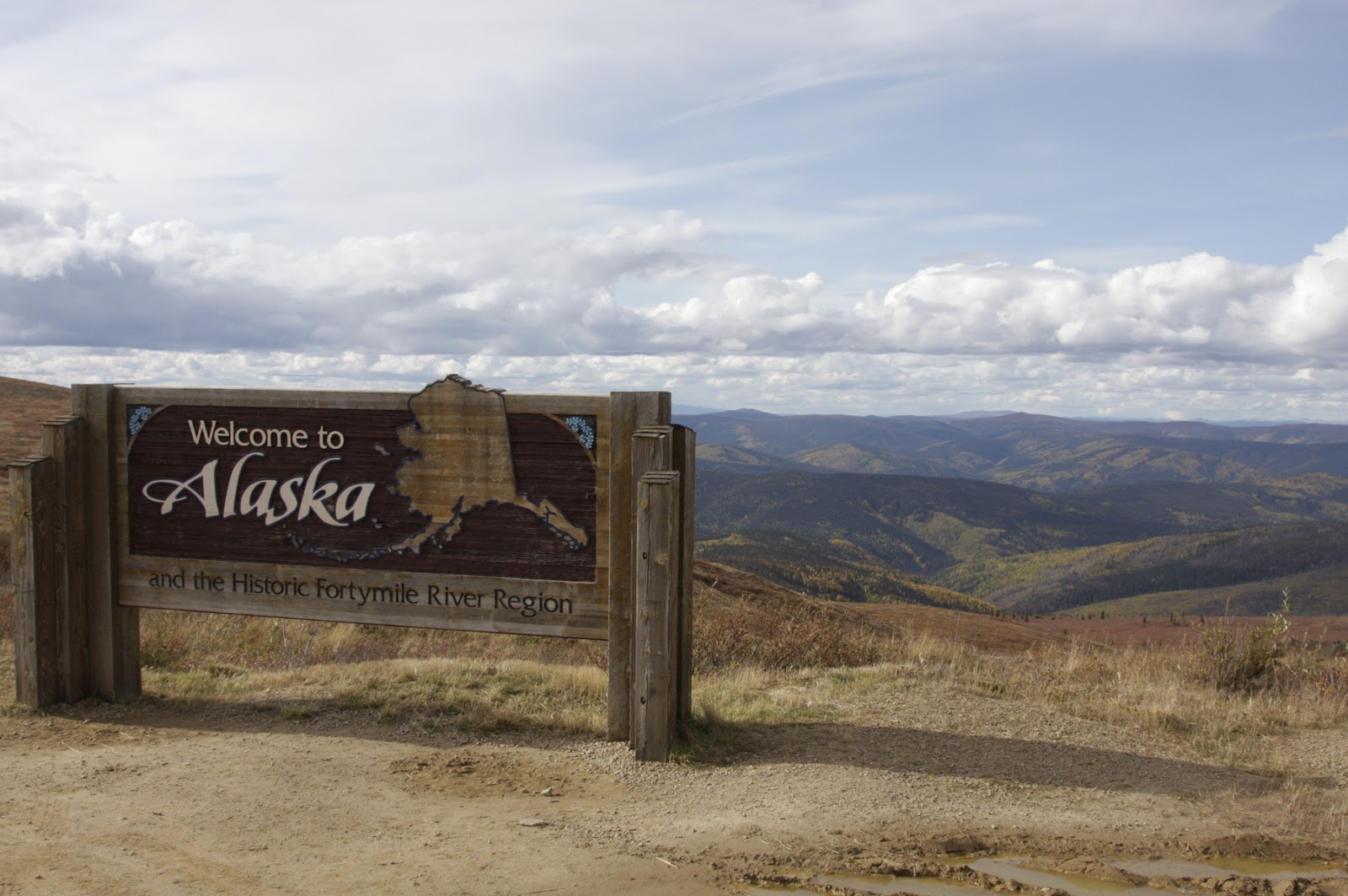
The drive over the Top-of-the-World highway was quite different from what we had remembered. The road surface is still gravel for the most part, but it has been rebuilt to better standards, and the views are outstanding. The greens we remembered had changed to a lot of dead, but still standing, spruce (due to the spruce bark beetle), interspersed with some live spruce, and much birch, glowing with gold and red leaves. Still beautiful, but very different from our memories.
 |
| Wayside near the Canadian border. |
 |
| And the beautiful 40-Mile country-side. |
 |
| Taken from right beside the sign-board, above. |
Then, just over the Canadian Border, but before arriving at Dawson City, the skies turned black, and the rain and hail poured down. The ground quickly turned white, and it was so noisy we could not listen to the audio book we had been playing along the way. It was quite intense for about 15 minutes as we plowed along in 4-wheel drive, pushing up the drifts of hail on both sides of the truck. I took it slow and easy, and eventually, we drove out of the line of showers and hail.
 |
A bit closer to Canada, and just before the hail-
storm crossed the road and hit us. |
Then the sun shown again, and we continued down the road, listening to our audio book again.
By the time we got to Dawson City, we had enjoyed the sun shine for quite a while and we had the extremely good fortune to drive up to the (free) ferry over the Yukon, just as it began loading for the 10 minute trip across to Dawson City. We boarded without any trouble, crossed over to Dawson City, and drove off the deck onto the shore.
 |
| Looking up-river, the Yukon is big; the ferry is small, but we made it across OK. |
 |
| Dawson City ahead. |
A quick look in town at the Visitors’ Center, a bite to eat at Sourdough Joe’s, and we were ready to head for the RV Park to set up for the night. This was the first night we had to use our head nets to keep the flies out of our face so we could get set up. This is how I looked when I walked in after finishing the job:
 |
| Head nets are sometimes a good thing to have... |
Saturday, 3 September 2011
Eagle's Rest RV Park
We had thought to spend the day sightseeing in Valdez, but didn’t see anything compelling to keep us there. We visited one place, the
Maxine & Jesse Whitney museum, which started as a gift shop collection in the 30’s. The Whitneys ran the gift shop while collecting all sorts of art and artifacts from all areas of Alaska and were quite successful in their business. Later, when they retired, they started the museum with the pieces they had kept. It was filled with interesting art and artifacts of all sorts, we enjoyed seeing the collection. Then a film started and we went in to sit down for it. That was a treat -- it showed Columbia Glacier in all its active glory, one calving event after another. If we couldn’t see the action in person, it was good to see it via the video. After that very interesting 40 minutes, we walked back to our trailer, and started on our way north to Tok. The drive up the highway went quickly, we saw real evidence of the advancing season along the Trans-Alaska Pipeline, north of Valdez:
 |
| The foliage was brilliant, this was the first real evidence of fall that we saw. |
Along the way, we drove through the Strawberry Lake NFS Campground where we stayed in 1997, and stopped at the Visitors' Center at the terminus of the Worthington Glacier.
 |
Terminus of one arm of the Worthington Glacier.
In 1997, it was an easy walk up to the ice; now it is a
real hike. The glacier has retreated nearly a mile. |
Further along, we passed more spectacular scenery along the Wrangell - St. Elias range, (though it was mostly in the clouds), and arrived in Tok in due course. We set up at the Sourdough RV Park, a bit south of Tok, and called it a day.
Friday, 2 September 2011
Tolsona Wilderness Campground, Glennallen, AK, USA
Since we had a 9:30 AM boarding call in Valdez, and we were camped in Glenallen, we got up early (4:50 AM) to have a quick breakfast, pack up the trailer, and hit the road. We were sorry to leave Tolsona Wilderness CG, but it was time to go. We drove down the highway to Valdez in increasingly bad weather, rain, wind, and low clouds -- it didn’t look good for the cruise, but we kept going. We pulled into Eagles Rest RV Park at 8:45 AM, checked with the office for a trailer space and mentioned our tight timeline for the Cruise at 9:30 AM. The lady at the desk told us that the Muir Glacier cruise was cancelled due to high winds in Prince William Sound; a real disappointment for us. Still, the cruise at 12:00 Noon for the Columbia Glacier was scheduled to depart normally.
We set up at Eagle’s Rest, and then went down to the Harbor area to look around and sign up for the Columbia Glacier Cruise. Then we looked around town a bit, until it was time to get in line for boarding the cruise. We gathered with about 120 others, under an awning, in the rain, waiting for boarding time. It was cold, windy, and rainy; not looking too good for the tour, but the crew said that conditions were improving at the glacier, so we said OK, and went aboard. We had good seats, at the front, port side. The departure was on-time, and smooth.
 |
| Leaving the Port of Valdez in the fog and rain. |
 |
| The view east from the Port of Valdez |
We sailed out of Valdez Harbor and down the channel into Prince William Sound. The Captain pointed out the sights, and spoke about the Exxon Valdez disaster which happened here in the late 1980s. We stopped briefly to watch sea otters, seals, eagles, and other wildlife along the shore.
 |
| Sea otter, looking us over. |
 |
| Trans-Alaska Pipeline terminal, and security marker buoy. |
 |
| Seals hauled out on the security marker buoy. |
 |
| Two of the many bald eagles we saw along the coast line. |
 |
| The face in the rock. |
 |
| The Port of Valdez Pilot's Hotel and ferry boat. |
For most of the time over the past 40 years, ice has been trapped between the retreating face of the glacier and the terminal moraine (now under 40 - 80’ of water). This year (and in a few past years), due to water levels, melting rates, and winds, the ice has broken free of the terminal moraine, leaving clear sailing up to within 3/4 of a mile to the face of the glacier. The face is so broad, that this placed us well within the arc that the face forms from one side to the other.
It was a spectacular place to be, and we were able to see and photograph a variety of small and large ice floes that had broken off from the glacier face, both above and below water. It made for a stunning vista.
 |
| Terminus of Columbia Glacier. |
 |
The darker ice was on the bottom of the glacier and
has picked up a lot of rocky debris. |
 |
| The blue is very pronounced, would be even more so in sunlight. |
 |
| Note the vertical stripe of a lateral moraine in the face of Columbia Glacier. |
 |
Another picture of the face of Columbia Glacier. I couldn't take
a series of pictures for a panorama due to fog and flat lighting. |
 |
| That looks like a squirrel in the ice, but I don't really think it is one. |
 |
| A more distant view of the terminus. |
 |
A crew-member fished out a piece of floating
glacier ice so we could see it up close. |
 |
| Amazing colors in the ice. |
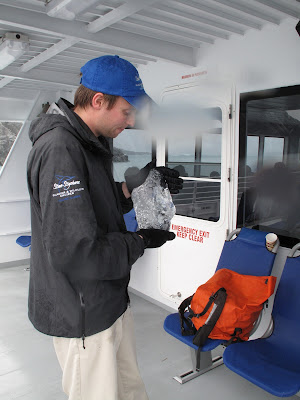 |
| Columbia Glacier ice, up close. |
 |
A working boat off the Columbia Glacier, taken
as we departed for the Port of Valdez. |
The only bummers were the weather (some sunshine would have been really great) and that for the entire time we were there, the glacier was quiet. So, no glints of sunlight on water and ice, and we didn’t get to see any huge chunks break off and fall into the water. Those were disappointments, but they didn’t dull the impact of seeing this immense glacier and the beautiful bay in which it terminates. Another great day in Alaska; but now we are at the far point of our trip, and tomorrow, we start back to Eugene; we will be headed north to Tok, Chicken, Dawson City, and thence homeward bound to points south. This has been every bit the adventure we’d hoped and planned for...
Thursday, 1 September 2011
Tolsona Wilderness Campground, Glennallen, AK, USA
I have already mentioned our pleasure at staying at the Tolsona Wilderness CG, I have to say, as well, that our day last Thursday was also a very good one. We were up, got breakfast, and made our way to Copper River Flying Service at the Gulkana Airstrip, by 9:00 AM. I checked in with Natalie and we discussed options for the day, since we hadn’t been able to make our scheduled flight on Wednesday. She suggested the all day mail-run trip, which would take us directly to the airstrip at McCarthy, give us a 4.5 hours to explore the village of McCarthy and tour the old (1930’s) Kennecott Copper Mine structure. Then, on the return trip to Gulkana Airstrip, we'd have an hours flying time around the Wrangell - St. Elias Wilderness. We thought that sounded like a great idea and signed up for the trip. That was more than we had planned when we left our trailer, so back to it we went to get different shoes and outer clothing.
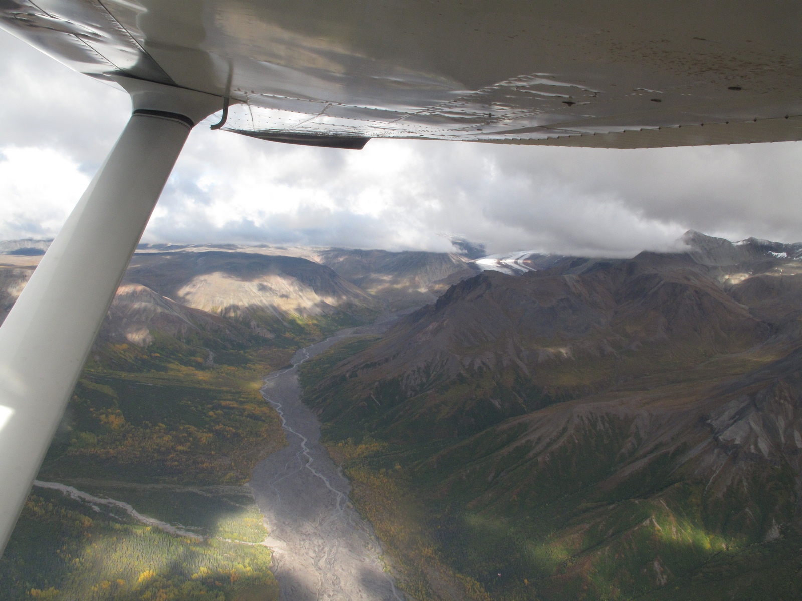
We made it back to the airstrip just in time for the scheduled take-off at 10:00 AM. We got our safety briefing, loaded into an already pretty full plane (mail piled up in the back and in place of the seat beside me, and another couple ahead besides us on the flight) and off we went. Anna, our pilot, took us up above the cloud layer and we got a good look at the tops of Mt. Wrangell, and surrounding peaks. The clouds looked pretty solid and she was flying a plane that was limited to Visual Flight Rules (a Cessna 206, with only basic instrumentation), so down we went to cruise just below the clouds into McCarthy. Along the way we saw lots of tundra and boreal forests, with lakes interspersed, and the Copper River valley. It was beautiful, as most of Alaska is:
 |
| Copper River Valley, on the way to McCarthy. |
 |
| Mt. Wrangell and Mt. Drum, above the cloud deck, just after takeoff. |
After about 45 minutes of flying time, below the clouds, we arrived at McCarthy. Here's what it looked like as we came into the airstrip:
 |
| Kennecott Glacier, with Mt. Blackburn in the background. |
We landed uneventfully and our ground transportation showed up a few minutes later. Unfortunately, the driver, David, didn’t have the program right, so took us directly to the Kennecott Mine site rather than to McCarthy where we were supposed to have some time to look through the old mining village. After a short discussion, he took us back down the road and let us out, right in the middle of beautiful downtown McCarthy:
 |
| Beautiful downtown McCarthy, AK, with derelict aircraft fuselage. |
 |
| Community Center, McCarthy, AK. |
 |
| Inn and Pub, McCarthy, AK. |
 |
| "The Potato" serves a good pulled pork sandwich. |
We spent about 15 minutes looking around the town-site, and then wandered over to “The Potato” -- the only restaurant in town that hadn’t shut down for the season. We ordered a pulled-pork sandwich and fries, split them both and were very satisfied. Then we walked through a bit more of the town, spotting some street art along the way:
 |
| A "safe" wine cellar and tasting room... |
 |
| The mine is no longer in production. |
A short time later, David picked us up, on schedule, and took us up to the
Kennecott mine site. There we met our guide, Larry, who gave us some background on the mine and the immense ore processing plant building that is still there.
 |
In front of the Visitors' Center our guide, Larry, tells
us about the the Park and the Kennecott Mine. |
Here are some scenes along the way to the entrance of the processing building.
 |
| View from the Visitors' Center towards Mt. Blackburn and the Kennecott Glacier. |
 |
The ore processing plant and bridge over Kennecott Creek. We entered
the ore processing plant at the top, just above the trees to the right in the picture. |
 |
The Chitina Auto Railer, used for passenger transport
and railway inspection in the 1930s. |
 |
| Buildings damaged in a major flood of Kennecott Creek. |
 |
Hospital building on right, assay office on left.
Kennecott Creek flooded several years ago, with
major damage to buildings and structures. |
 |
| Looking back toward the Visitors' Center. |
Then we walked an outside trail up to the top of the ore processing plant (it is built up the side of the mountain), and at the entrance, received a safety lecture and our hard-hats (which were indeed needed and useful). We saw the remains of the overhead bucket lines that brought the copper ore down from the mountain tops where it was mined to the crushers and separation tables where the copper ore was crushed and then separated from the limestone matrix in which it had been embedded. It is quite a process, and much of the necessary machinery is still in place in this huge old building. The most valuable bits (wiring, electric motors, controls, etc.) have been removed, but much of the heavy machinery is still in place. These pictures give a sense of the site, but the best way to see it is to visit in person:
 |
Owner's home at the right, ore processing plant behind. We
walked up and toured the home, and then took a path
to the right of the home up to the plant entrance. |
 |
A reflection in one of the windows in the owner's house.
This is very old glass. |
 |
| View from the plant entrance, looking towards Mt. Blackburn. |
 |
The top floor of the ore processing plant. The copper ore
arrived here by tram buckets running on cables that went up the
mountain to the mine sites located much
higher on the mountain. |
 |
View of the leaching plant, down below the crushing, sorting and
initial separation area of the plant. |
 |
Gearing and roller mill, ore was crushed in this
machine, and then sent down chutes by
gravity to the sorting tables. |
 |
The tour group inspects sorting tables that automatically separated
copper ore from limestone waste. The tables were flooded with
ground ore suspended in water, vibration and a tilt in the table
caused the ore (heavy) and the waste (light) to separate along
grooves in the table. Larry (left) is explaining to us how
it all worked, back in the day. |
 |
Well, maybe it isn't all in such good shape.
The foundation is rotting and about to
collapse in some places. The National
Park Service is working to shore up
such places and limit the damage. |
The National Park Service owns the property now, and is committed to maintaining it in a (reasonably) safe condition. There is restoration of some of the buildings planned and in progress and also basic shoring up of structures to insure they remain intact. So, it is an active place.
 |
A new foundation is being placed below one of the bunk-houses. It will
become NPS staff housing and additional display space. |
We spent a very quick four hours peering into all sorts of dark corners, discussing the purpose of the various bits of heavy machinery, and walking down many steep flights of stairs to get from the top floor to the base of the plant building. When we came out, there was more to see (leaching vats and piping for the final chemical separation of copper salts from base material), but we elected to see a movie at the NPS Visitors’ Center instead. It was a good choice; the movie filled in numerous details and showed interesting shots of the mine in action.
In all, a very interesting afternoon, but the best was yet to come. David took us back to the airstrip, and Anna was waiting for us. We loaded into the plane again, and this time I got to sit up front in the co-pilot’s seat. Anna took us up and then, since the cloud deck had broken up quite a bit, she proceeded to give us a spectacular look at the mountains and glaciers in the Mt. Wrangell range. We flew up to the peaks, across high ridges, and down glaciers for 45 minutes as she described what we were seeing; a glorious time, indeed. I just wish my pictures could do it justice. I’ve included a selection that come as close as I can, enjoy:
 |
Mt. Blackburn (background) and terminus of the Kennecott Glacier in front
of the Kennecott town-site (just after take-off from the airstrip). |
 |
| Kennecott Mine site, Kennecott, AK. |
 |
| Kennecott Glacier. |
 |
| Mt. Blackburn & Kennecott Glacier. |
 |
| Excellent view of lateral moraines on top of Kennecott Glacier. |
 |
| Mt. Blackburn Summit. |
 |
| Summit & glacier. |
 |
| At the top. |
 |
| Awesome! |
 |
| Up close and headed for the next valley to the west. |
 |
| Summit from another angle. |
 |
| At work in the office (and what an office). |
 |
| With a view! |
 |
| More glaciers. |
 |
| And a beautiful lake. |
 |
| Summit of Mt. Drum. |
 |
| Glacier, below Mt. Drum. |
 |
| Now we are on the way back to Glennallen and Gulkana Airstrip. |
 |
| Rugged country. |
 |
| But not totally empty of life; the small white dots are Dall sheep. |
 |
| A mud volcano and mud flows around it, enroute to Gulkana Airstrip. |
Finally, we arrived at Gulkana Airstrip and landed; the end of a real Alaskan adventure.
 |
| Anna, beside the Piper 206 she flew into McCarthy and return. |
 |
| Wrangell Range from Gulkana Airstrip. |
That evening, back at our trailer, I called up Stan Steven’s Cruises in Valdez to see what our options might be for a glacier cruise. We signed up for the 10:00 AM - 7:00 PM cruise to the Muir Glacier. Next, I checked with a couple of RV Parks and got space at the Eagle’s Rest, so we knew where we were going next. Then we called it a day.


Beautiful pictures of Alaska, etc.
ReplyDelete