This short section suggests a way to get into and use this blog.
The tabs at the top of this page are: Home (this section), About (some context information about the blog and the trip), and Pictures Page (more pictures, too many to post in the main part of the blog, but available if you are interested).
My suggestion is that you click on the About tab, and take a look at the context information. Then come back here and explore the trip blog as you wish. Enjoy!
Warm regards,
Lin & Don Hirst
Monday, 19 September 2011
Home, Eugene, OR USA
Wow! What a trip! We are home safely, some 8,400 miles later. It feels really good to be home; that said, we are both glad and sad that our Alaska Trip 2011 is finished.
 |
| Home, again, and safely. A wonderful time and we're both glad and sad that it is over. |
After safely arriving home, next we had several of days of unpacking, cleaning up, and taking care of some minor repairs. Then I had to sort through something like 3,400 pictures and select the best among them to update this blog. It took several weeks to complete the job, but the effort brought back a host of wonderful memories. Also, I've finished editing the blog to make it more consistent and correct some grammar, so the writing is done, finally. Enjoy.
Our last 120 miles was nostalgic, we’ve been across OR 126 from Sisters before, and it is a beautiful drive. We left from Cold Springs CG at about 9:30, stopped for lunch at the Vida Café for a burger and some of their delicious triple berry pie with ice cream. That meant we were really home again. Then the familiar sights of Springfield and Eugene were in front of us and finally, our home. It feels good to be here; we are glad that we made the trip and that everything worked out well, pretty much as we had planned it. Now all we have to do is figure out what our next big trip will be, and when.
We hope that you will enjoy reading this blog. We'd love to have your thoughts and reactions to it.
The blog didn’t get updated on a daily basis for a number of reasons; some to do with lack of or problems with Internet access, others with our focus on enjoying the time we had away from home. Now, it is all done. We’ve enjoyed writing it; a fitting remembrance of a wonderful two months in our lives.
Cold Spring CG, Deschutes National Forest, Sisters, OR USA
Up, and getting ready to head for home! Hard to believe this is our last day. This is a beautiful site, and easy to revisit...
 |
| Our site in Cold Spring CG, right beside a small stream. |
Additional pictures from our trip are available on the Pictures Page. I've placed the additional pictures on a separate page to make the blog shorter and more readable. Enjoy!
Sunday, 18 September 2011
Cold Spring CG, Deschutes National Forest, Sisters, OR USA
It is a beautiful afternoon, we are camped at Cold Spring CG (NFS), a few miles west of Sisters, OR. I am catching up on this blog, while Lin is taking it easy reading a book in her camp chair. It is quiet, the breeze in the fir trees is keeping us company; no one else nearby. What a wonderful way to end our Alaska adventure. Tomorrow, we will close this out as we head for Eugene and home. Here’s what’s happened the past few days...
Saturday, 17 September 2011
Bend-Sisters Garden RV Resort, Sisters, OR USA
We packed up our trailer at Yakama Nation RV Park, and left for a quick look around Toppenish and Zilla, the small towns nearby. They are part of the wine route around Yakima, but we figured we’d had enough wine up in the Okanagan, so we were just looking around a bit. Both towns are small, with not much happening on a Saturday morning. We headed back to the RV Park and hitched up to head south. We thought to stay a night at Maryville State Park in the Columbia Gorge, a park we know and like a lot. Well, there was a concert over the weekend at Maryville Winery, and there wasn’t an open site in the entire Gorge. So, we just kept going, arriving in Sisters about 4:30 PM. A quick look around led us to the former KOA, now called the Bend-Sisters Garden RV Resort, just south of Sisters. We pulled in and set up for the night. It is a nice park, well laid out and with reasonable space between sites. But it is all grass and asphalt, not what we think of as camping. So, just one night there.
Friday, 16 September, 2011
Yakama Nation RV Park, Toppenish, WA USA
The drive from Osoyoos, BC down to near Yakima, WA passes through high desert with all of its sere beauty. It is not particularly our preference, but we kept on going through it to Toppenish. There we found a place at the Yakama Nation RV Resort. We set up and called it a day. After a quick dinner, we took a walk around the park, not someplace we’d revisit, except by need. And that was the day.
Haynes Point Provincial Park, Osoyoos, BC, Canada
Friday morning, I was up early and took a few pictures around our site and the campground.
 |
| The end of Haynes Point spit, looking east. |
 |
| Along the north shore of the point, looking NW. |
 |
| Same position, looking N. |
 |
| South shore, looking, SW. |
Then we had breakfast, packed up, and were on the road in good time. We were sorry to leave this beautiful part of Canada, so I think we will return and spend more time in the Okanagan region.
Thursday, 15 September 2011
Bear Creek Provincial Park, Kelowna, BC, Canada
Today we’ll be leaving Bear Creek Provincial Park, a former logging storage spit that was made over into a very pleasant small park on the west shore of Kelowna Lake, about 5 mile across the lake and north from the town of Kelowna. We arrived here on Tuesday, after looking at the RV Park I’d picked out from the guidebook and deciding it wasn’t our cup of tea. We much prefer to camp in national, state, or provincial parks, not RV Parks that don’t provide space, outdoor fire pits and real picnic tables. The one big difference is that the RV Parks generally provide electric power, water, sanitation, and most times WiFi Internet connections. None of these generally show up in government run parks, so there is a tradeoff.
 |
| Bear Creek PP |
 |
| Greata Ranch Estates Winery. |
 |
| Greata Ranch Estate - Tasting Room. |
 |
| View to SE from Greata Ranch. |
 |
| View to NE from Greata Ranch. |
Wednesday, 14 September 2011
Haynes Point Provincial Park, Osoyoos, BC, Canada
This evening we are at Haynes Point Provincial Park; it’s a lucky day for us. We drove in about 12:30 PM after a slow drive down from Bear Creek PP, with stops at several wineries along the way, some wonderful views of lakes, mountains, and high desert, and, oh yes, some excellent wines (see pictures, above). On arrival, we saw the sign at the entrance; “Campground Full.” Well, we took a chance and drove through, and found the one open site. We pounced on it and set up, lucky us. It was the only open site for the rest of the day. After getting set up, we headed north to the Osoyoos Visitors’ Information office. There we picked up literature and talked with the receptionist. She suggested lunch at Burrowing Owl Winery, and seconded the other winery selections we’d already made for visits. We took off up the road and found Burrowing Owl without any problems. We wandered through their observation tower while waiting a few minutes for an outside table, drinking in wonderful views in every direction. The lower Okanogan Valley is a beautiful area, and we savored every moment of the warm sunshine.
 |
| View from Burrowing Owl observation tower, looking SE. They have a very nice restaurant, and the Inn is beautiful as well. |
 |
| View from the observation tower, looking SW. |
Bear Creek Provincial Park, Kelowna, BC, Canada
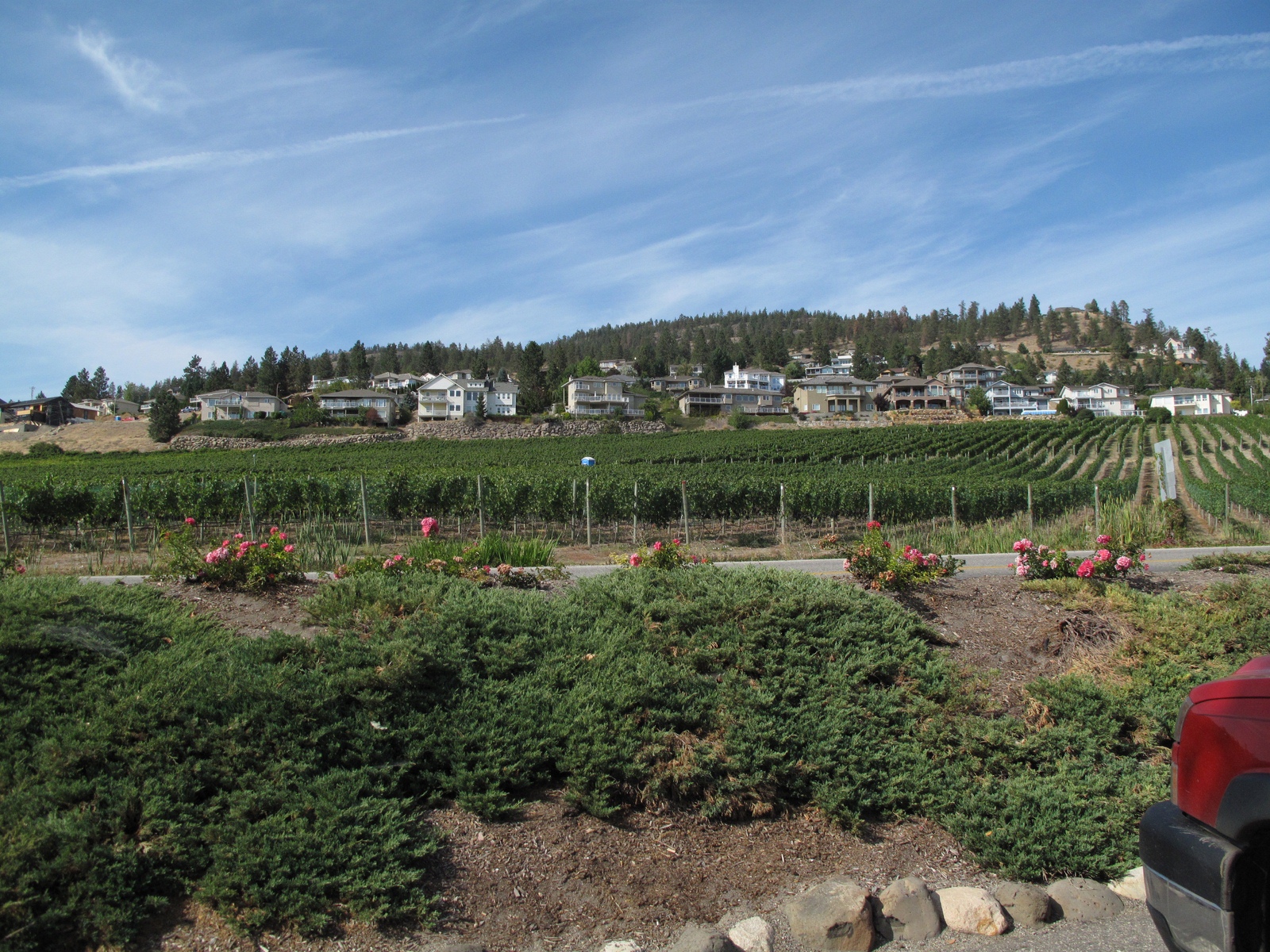
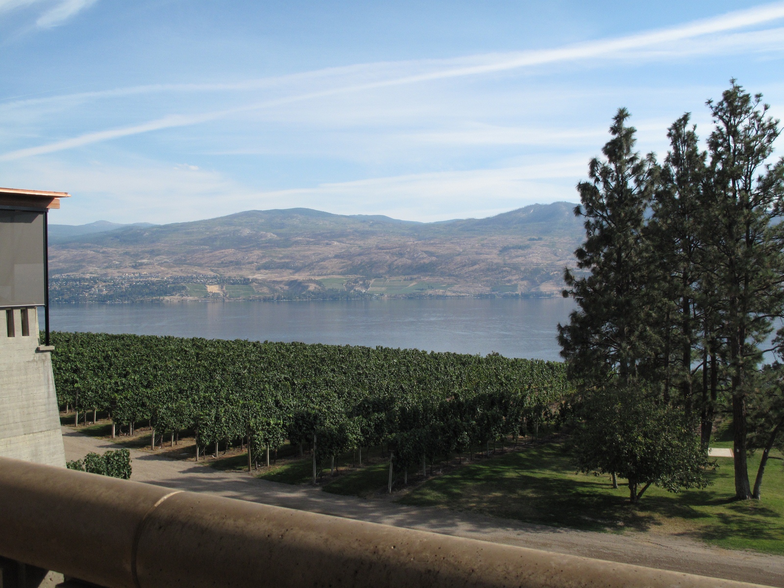
We woke up to a beautiful morning, sunny and warm; what a pleasant change from last week. We decided to spend the day looking through downtown Kelowna, visiting the local Tourist Info office, and then exploring vineyards in the area. It was a good plan and worked out very nicely. The town of Kelowna is a pleasant place, with lots of shops, restaurants, and a wonderful location along the lakefront. We visited the Calona winery in town and began to realize the buzz about this area’s wines is the real thing. From there, we headed south on the east side of the lake and visited Summerhill, Cedar Creek, and St. Hubertus wineries, and had lunch beside a very lovely little lakefront park. We found some excellent wines as well. Then we headed over to the west side of the lake, and visited Mt. Boucherie, Quails’ Gate, and Mission Hill wineries. All have spectacular locations, on both sides of the lake and provide superior wines. We could also have dined extremely well in most of them, if we had wished. We drove back toward our trailer for a nap and some down time; along the way, we drove north along the west lakefront, passing by some spectacular homes, and then a wild park area. There we saw a group of mountain goats grazing along the roadside, including one magnificent ram with a full curl of horns (sorry, no pictures). Then a nap, some work on pictures, and a quiet dinner. A wonderful fine day, one of the last, as we will be home soon. Here are some pictures from our day:
 |
| Kelowna Lake, with Bear Creek PP in the center. |
 |
| Kelowna Lake, west shore. |
 |
| The old man at the Summerhill Winery. |
 |
| View from Summerhill Winery Terrace, looking NW across Kelowna Lake. |
 |
| Summerhill Winery - Pyramid Wine Cellar. |
 |
| Inside the pyramid. |
 |
| The quartz crystals and copper strips that "shield" the interior of the pyramid. |
We visited several other wineries on the east side of the lake, and then drove back north and across the bridge to the west side of the lake. Lots more to see down into West Kelowna; beautiful sights and good wine.
 |
| Pinot Noir grapes at Quail's Gate. |
 |
| Looking west, up the hill at Quail's Gate. |
 |
| The grounds at Mission Hill, a really spiffy place. |
 |
| A view SE across the Lake from Mission Hill. |
 |
| And a view NE from the end of the gallery seen above. |
After dinner, we took a short walk along the lake's edge.
 |
| Looking from our campground across Kelowna Lake at night. |
Tuesday, 13 September, 2011
Irvine’s RV Park, Valemount, BC, Canada
Tuesday was a travel day. We enjoyed our stay here, but now it's time to move on:
The Valemount area is beautiful, with snow-topped mountains surrounding the valley floor, well worth a revisit.
The drive south to Kelowna was just that, several nice rest stops and some beautiful scenery along the way. We continued to listen to our audio books, working our way through Anne Perry’s series of stories about Thomas Pitt (a police detective) and his wife, Charlotte, who helps out with investigations. The stories are set in late 1800’s London and give interesting vignettes of Elizabethan English life of that period. They certainly help the miles pass more quickly, and finally we arrived in Kelowna. The GPS routed us through some side streets on the north and east of the town, so we picked up some produce at a roadside stand, and eventually found our planned RV Park. It was definitely urban and crowded; by the time I added in the cost of WiFi Internet access, it was also too spendy for our tastes. So, we looked into the guidebook, and decided to see if Bear Creek Provincial Park was more to our liking. It turned out to be a very nice small park on the west side of Kelowna Lake. We found a beautiful open site, and set up for a two night stay; and are very glad we did. So ends the day...
Monday, 12 September 2011
Crooked River PP, Bear Lake, BC, Canada
In the morning, before leaving Crooked River PP, we took some time to walk the western shore path along Bear Lake. It was a lovely walk:
 |
| Squirrel gave us a good scolding! |
 |
| Beach and kayakers on a lovely morning. |
 |
| Bear Lake, looking back toward our camp site. |
The drive from Bear Lake / Crooked River PP south to Valemount passes down the Salmon River valley, a beautiful area, and into St. George. We stopped for a while in St. George to look around and do some shopping. Then we headed further south to Valemount. It was just a long day, nothing special to say about it. The CG at Valemount was north of town, quite a nice one, but of the commercial variety rather than the forest campgrounds that we prefer. We set up, and asked about a good local restaurant. The RV Park owner, enthusiastically seconded by several others in the office, suggested the Caribou Creek Grill in town. We had diner there and enjoyed it greatly. We had received good advice; it was a very nice restaurant, big wood log walls, nicely spaced tables, interesting objects on the walls, excellent service, and a delightful dinner. Definitely a place worth another visit, both for the food and the surrounding countryside.
Sunday, 11 September 2011
Northern Lights RV Park, Dawson Creek, BC, Canada
Strange to remember those terrible days 10 years ago, the world is certainly different now...
We left Dawson Creek at about 10:00 am, planning to stay at Whiskers Point Provincial Park on McLeod Lake Monday night. The drive south on BC 97 from Dawson Creek to Valemount is a beautiful one. It passes through an area of rolling hills, with lakes, and further south, mountains. There are a series of small, but very picturesque provincial parks along the road. We went in and out of several, just to see how they looked. BC does a very nice job with their parks, and we’d like to come back to revisit some of them. When we reached our planned stop over at Whiskers Point PP, on MacLeod Lake we found it closed. The next alternate was about 60 miles further south at Crooked River PP. We kept going till we came to it and were glad we did. The CG is on Bear Lake, a small, but quite pretty lake, very clear and with a nice sandy beach area. We set up and made dinner, so nice that we were able to enjoy our dinner outside; all very peaceful.
After dinner, we walked down to the lake shore and enjoyed a few quiet minutes watching the moon rise in the east:
 |
| Bear Lake, about 7:45 PM; a beautiful, peaceful place. |
 |
| North shore of Bear Lake, a nice beach to revisit. |
Lin wished we could stay a second night here, but I confess a certain eagerness to be headed towards home, so we took time in the morning to walk around part of the lake, and then packed up to get on the road again.
Saturday, 10 September 2011
Northern Lights RV Park, Dawson Creek, BC, Canada
We took the day to wander around Dawson City sightseeing and shopping. The Visitors' Information Center is in the old railroad station, along with a nice museum. Back a few years the RR was the sole link to the outside world. The the station-master’s office is set up with all the original equipment; it is interesting to compare now (sleek electronics everywhere) with then (all in black, large, blocky), but it clearly got the job done for a long time. We watched a video of the building of the Alcan Highway - an immense feat in the early 40’s, and even today a marvel of engineering; fun to drive, and challenging, still.
 |
| Dawson Creek RR Station, Visitors' Center and Museum. |
Next door, there is an old grain elevator that has been converted into an art gallery. The interior is a spiral ramp up several floors to provide space for hanging artworks. Three women had a show on, with water colors and pastels of nature and people, interesting material well done, we enjoyed walking through it and seeing how they interpreted the scenes of the area.
 |
| Town art gallery in the old Grain Elevator. |
The downtown was active, with a good mix of shops and some tourist spots. This is clearly more than a tourist town, though; we enjoyed our stroll:
 |
| Mile Post "0" on the Al-Can Highway. |
 |
| Note the murals on the north wall of this fancy old hotel. Many of the old buildings in town are decorated with interesting murals of scenes from the old days. |
Southwest of town, there is a wind-power installation, with 34 huge wind turbines along a high ridge. It is an interesting sight, not so usual in Canada, but one we are familiar with from our stay in The Netherlands, where wind-power is a commonplace. There is a commemorative book published about this installation, and it is touted as a park area as well, so we drove up to it and looked around. Not much of a park, but an interesting visual sight. And a bit strange to sit in the truck below one of these immense stalks, listening to the wind whistle over the blades as they swish by, with random groaning sounds as the yaw motors turn the nacelles to keep the blades facing the wind. Each one is independently controlled, and as you look along the line, the unit above you may be facing directly west, while the units at the other end of the line are almost head on to you. Interesting to watch for a bit.
 |
| Wind-farm, unusual in Canada, but wide-spread in other regions. |
 |
| Interesting paint job on the bottom of the pylons. |
After our look at the towers, we drove back into town, did a bit of shopping, and called it a day.
Friday, 9 September 2011
Northern Lights RV Park, Dawson Creek, BC, Canada
Dawson Creek is Mile / KM “0” on the Alcan Highway, and that’s where we are this evening. We’ll take a down day tomorrow, and look around the town before heading further south. Mostly, we have been traveling since leaving Valdez. That won’t change much until we are down to the Okanagan Valley, in southern BC. We’ll stop there for a couple of days to look around the area, which is reputed to be beautiful, and with many good wineries. We are curious to explore that area. For the rest, I’ll include brief notes of our travels...
3G's Hide-away RV Park, Ft. Nelson, BC, Canada
Friday was another mostly travel day; we were up and packed early, then walked next door to the Ft. Nelson Historical museum. They were closed for the season, already, so we walked around the outside. They have many old engines, large and small, and a fair amount of mining hardware, but most of their collection was in closed buildings; a disappointment. We had looked over the local activities and didn’t find anything of more interest, so off we went, on the road for a long day’s drive. This was the day that took us from the northern edge of the Rocky Mountains onto the rolling hills and farm country of the high, intermountain plateau. The change is quite remarkable and a major shift in the landscape. Also, the weather improved dramatically. We’d been under mostly cloudy skies, with showers, and finally, the sun came out with only a few clouds to be seen, and for the first time in six weeks, the temperature climbed above 70°F. We are very glad to see this change. We took a few breaks along the way, and then about 10 miles west of Dawson Creek, we ran into a very long line of stopped traffic. After an hour, we reached a point where we could turn around and did so. We went back past several miles of stopped cars and trucks, and finally found a through road south to another highway. We took it, and then an east bound road which brought us back to the Alcan; which by that time had finally cleared out. So we got to our RV Park an hour+ later than expected, but with no further trouble. That’s it for Friday.
Thursday, 8 September 2011
Baby Nugget RV Park, Nugget City, YT, Canada
Thursday, I took some time before leaving the Baby Nugget RV Park to spray wash the undercarriage of our travel trailer (it still was carrying dirt and gravel from the Top of the World Highway). Then, we drove from Nugget City, a few miles west of Watson Lake, YT, to Ft. Nelson, a distance of 340 miles. It was a long day, with the most notable stop being the Sign Post Forest in Watson Lake. We stopped and looked around for a bit, finding a sign post for Eugene, and many others of interest.
 |
| Just a few of the huge number of sign posts. |
 |
| Here's Eugene! |
 |
| Lots more to see. |
Then we were back on the road, it was a good day for spotting wild life, we saw a good size black bear and then several of them in a group (much smaller bears than the browns we saw in Katmai), a herd of bison, then several caribou, and finally a small herd of mountain goats by the road.
 |
| A good size black bear. |
 |
| A family of black bears. |
 |
| Old man bison, and his herd. |
 |
| And some caribou. |
 |
| ... with fawn. |
 |
| Finally, some mountain goats. |
Also, we saw much beautiful scenery during the long day’s drive. We eventually arrived in Ft. Nelson, and found a place to stay at 3G’s Hide-away RV Park, set up, and shared a quiet meal. Afterword, Lin read for a while and then went to bed. I stayed up a bit later, working on my picture files and uploaded the first batch to the blog. That was it for Thursday...
Wednesday, 7 September 2011
North Country RV Park, Whitehorse, YT, Canada
This travel day we drove from Whitehorse, YT to Nugget City, YT, a few miles west of Watson Lake, YT. Before leaving Whitehorse, we took some time to walk a bit, and drive through the downtown area to see what was there, anything that we might have missed on our walk through the area. It is a small town, during the summertime there are a lot of activities for visitors, but by the 2nd week in September, things are getting very quiet. So, we packed up and headed south, again. The scenery along the drive was as spectacular as ever; broad valleys covered with spruce, and golden alders and aspens in patches along the mountain-sides; beautiful country, but so empty of people and activity.
The crossing at Teslin, YT is particularly nice:
 |
| Teslin Lake. |
We arrived in due course at the Baby Nugget RV Park, which is a basic park set on loess soil and gravel. There are sparse trees and it was mostly empty by now. We looked in the restaurant and decided that we’d make our own meals, thanks very much...
Tuesday, 6 September 2011
North Country RV Park, Whitehorse, YT, Canada
We are now beginning a stretch of mostly driving to get us back south. Our next major stop-over will be in the Okanagan Valley, where we are much closer to home, and are interested in exploring a bit for further visits in the future. The start of this stretch took us from Carmacks to Whitehorse in the Yukon Territory. This is still a remote, wilderness area with little development, rough roads, and long distances between stopping points. We saw a number of closed and abandoned road houses and fueling points; only a few of them remain active now. The mountains are less steep and rugged than further north, but the scenery retains its interest. We arrived in Whitehorse about 2:00 PM, ate our lunch (late) and set up. Then we went into town, checked out the VC, found many attractions already closed, so went for a walk around the downtown area. It seems a thriving community, nice murals on some of the buildings. A short drive around the lake south of town took us back to our trailer for dinner and a good night’s rest...